Lizmap
Create Web GIS application with QGIS
QGIS Indonesian User group
🦎
21/11/2020
Etienne Trimaille
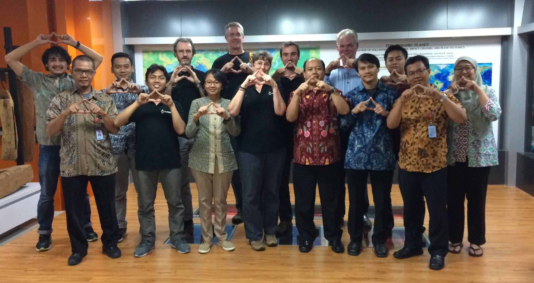
InaSAFE 2015 - 2018
3Liz
- Open Source forever
- QGIS and PostgreSQL lovers 🐘
- QGIS core contributors (mainly server)
- 8 employees
- QGIS / QGIS Server / PostgreSQL / Lizmap
- Development, server hosting, consultings, support, trainings
![]()
QGIS
The leading Open Source Desktop GIS
![]()
QGIS is a professional GIS application that is built on top of and proud to be itself Free and Open Source Software.
QGIS Desktop
Many capabilities
A lot of styles 🎨
Report generation 🖨
Data analysis 📈
Forms
QGIS
- Was a simple PostgreSQL/PostGIS viewer 🐘
- Licensed under the GNU General Public License
- Project of the Open Source Geospatial Foundation (OSGeo)
- Runs on Linux, Unix, Mac OSX, Windows and Android
- Supports numerous vector, raster, and database formats and functionalities.
QGIS is not only a Desktop app
- QField a mobile [Q]GIS solution
- QGIS Server as an OGC Data Server
- QGIS Processing console tool (on a server or not)
![]()
Need to publish web maps ?
- You already use and love QGIS
- You need to publish a full-featured Web-GIS application
- Complex legend
- Print layout as PDF
- Attribute table
- Access rights
- You have no time to set up and configure web maps in complex admin panels nor reinventing the wheel
![]()
Lizmap ♥ QGIS
WYSIWYG
What
You
See
Is
What
You
Get
No Code needed
(Or nearly …)
Lizmap 💕 QGIS
- The QGIS desktop project is your web map configuration: symbology, printing composers, attribute tables, editing forms, expressions, etc.
- As QField, Prepare once deploy everywhere
- Lizmap QGIS plugin: configure only specific map options (scales, available tools)
- Web admin panel mainly for authentication and authorization management (users & groups)
- It is open-source: Mozilla Public Licence on GitHub
![]()
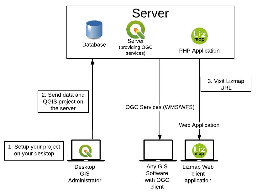
How-to publish a web map application
🗺
Create and set up your QGIS project
Layers, PDF Layouts, forms…
Use Lizmap QGIS plugin
Map options and tools (extent, scales, …)
Send your QGIS project on a server
Lizmap configuration, data and others files
😲 You’ve got a web map based on this QGIS project 😲
Under the hood
Use cases
Some examples to demonstrate
the main features
Meylan - map catalog
- French city in the Alps
- Publish thematic maps for citizens
- Eye-candy, with a focus on simplicity
Calvados - Custom theme
- French department of Normandy
- Publish thematic maps for citizens
- Promoting landscapes
Aduga - Popups
Identify an object
- Urban planning agency
- Highlight key figures of local business parks
- Use Lizmap HTML popup with QGIS tooltip & expressions
Edition - Faunal observations
- QGIS field edit widgets
- QGIS Form drag&drop conception
- Draw geometry - GPS use capabilities to draw
- Edition rights
Borbonica - Dataviz
- La Réunion National park (Indian ocean)
- Publish a dashboard on animal observation data
- Use Lizmap dataviz module with PostgreSQL views
Cats - relations and atlas
- Movebank public dataset on domestic cats positions
- Show relations between layers data
- Use QGIS relations in the project properties dialog
- Add attribute tables in Lizmap plugin for these layers
- Iterate over cats with the atlas tool

Grand Narbonne - find local products
- Promoting local shops
- Promoting local products
Cadastre - business application
- French Britanny group of cities: Centre Morbihan Communauté
- Search parcels by location or owner information
- Dedicated Cadastre Lizmap modules with a QGIS Server Python plugin
- Lizmap native access control to protect sensitive data
A growing community
- Different types of users
- private companies
- public organizations
- research centers
- Main contributions in translation and documentation
- JavaScript scripts repository contributions
- Bug triaging
🇫🇷 🇵🇹 🇧🇷 🇨🇿 🇮🇹 🇭🇺 🇳🇱 🇪🇸 🇵🇱 🇮🇩 🇫🇮 🇸🇪 🇩🇪 🇷🇺 🇬🇷 🇹🇷 🇸🇮 …
Freely usable and used
- Bonelli eagle 2017-2019 http://lizmap.aigledebonelli.fr/websig/lizmap/www/
- Indian ocean environment survey http://homisland.seas-oi.org/
- IRSTEA Earth Observation: https://mdl4eo-cartes.irstea.fr
- Georice, South-East Asia: http://georice.net/lm/
- Faunalia (Italy) https://lizmap.faunalia.eu/
- Consorzio Toscana Nord (Italy) http://geoportale.cbtoscananord.it
- Live QField users map: http://demo.qfield.org/websig/lizmap/www/
- Município de Arraiolos (Portugal) http://pdm-revisao.municipioarraiolos.pt/
- SAERI (South Atlantic): https://data.saeri.org/saeri_webgis/lizmap/www/
Extensions
- QGIS Server plugins
- Server sides Lizmap modules
- Map builder
- WPS
- User Javascript scripts
- CSS themes
- HTML powered : iframes, video/audio, etc.
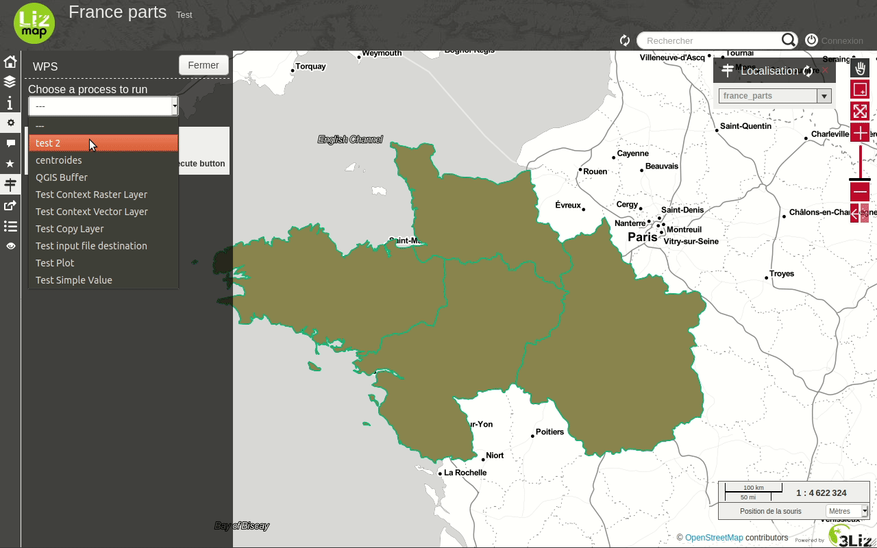
WPS : Web Processing Service
Export QGIS Toolbox on the web
Next Lizmap release : 3.4
Next week ! 🥳
- Use QGIS Expression in Lizmap Edition
- default value, constraints, drill down, fields group display
- Snapping while editing
- Geolocation survey
- Improvements in dataviz
- Lizmap plugin as a QGIS Server access control plugin
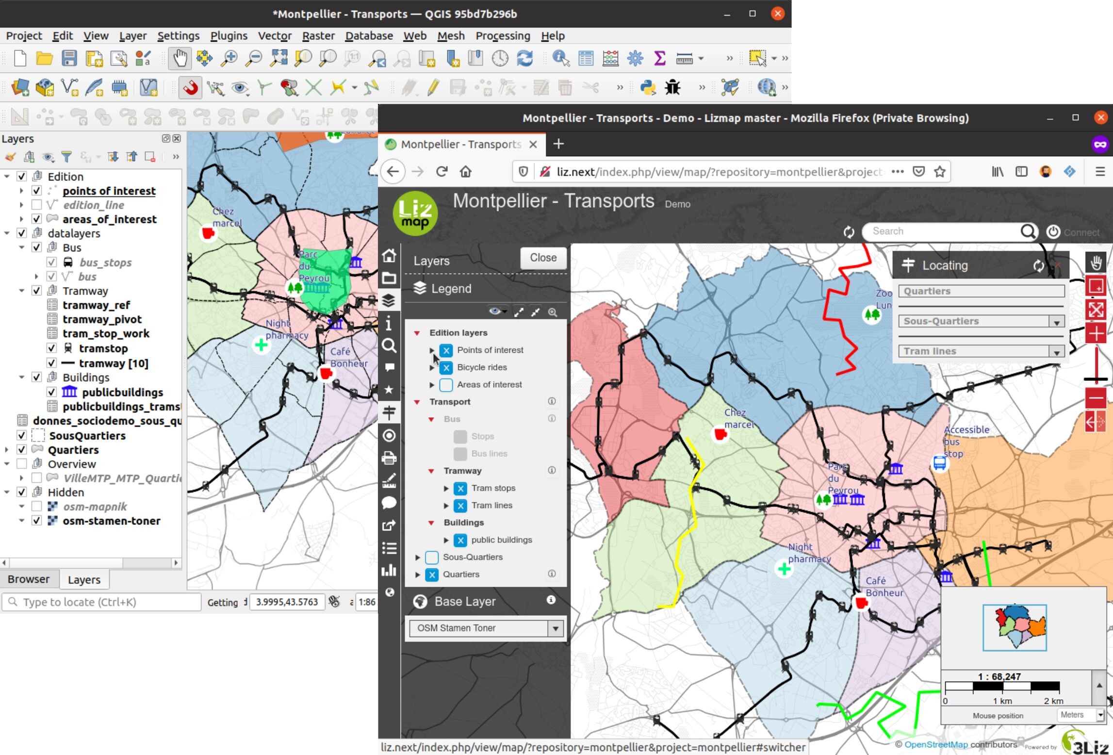
Demo
😛
…
😕
Social media
Links
QGIS Swiss User group 🇨🇭
24/11/2020
New features in Lizmap 3.4
Terima kasih
Sampai jumpa !